Predicting the unpredictable

© 2005 Brienz Creative Commons
EPFL scientists have developed the first system to issue early-warning alerts for landslides. Early-warning systems like this are already in place for other natural disasters such as tsunamis and tornadoes.
In a mountainous country like Switzerland, landslides are not uncommon. Unstable slopes cover about 6% of the country’s total land area. And with global warming, these events are expected to occur more frequently. As precipitation increases and glaciers melt, more water will be flowing in the mountains; this could potentially trigger landslides in new areas.
John Eichenberger, a PhD student in EPFL’s Soil Mechanics Laboratory, has spent four years under the direction of Professor Lyesse Laloui developing a tool that can reproduce the behavior of steep slopes when subject to heavy precipitation. Research was conducted in both the laboratory and the field, in particular on the slopes of the Rhine River, where he coupled sensors to a computer model. The model was able to accurately detect when the saturation state of the soil reached dangerous levels, thus allowing an early warning to be given.
These data provide a valuable source of information for protecting the population of a mountainous area such as Switzerland. The researchers also studied other regions in the world with very different soil types, such as the steep slopes of a volcano in Costa Rica.
The infiltration of water
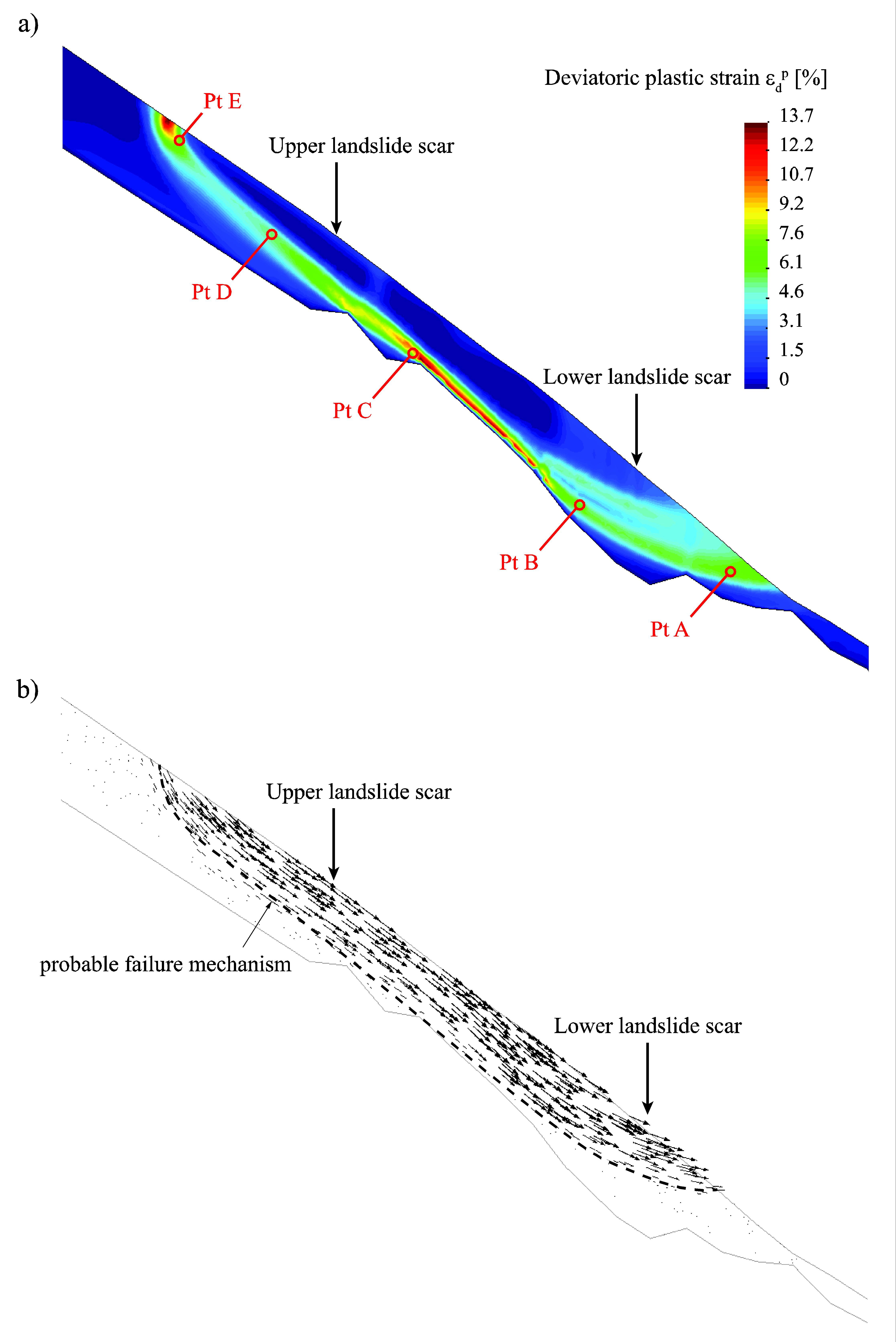
It is very difficult to predict the intensity of a landslide. Experts generally categorize them as one of two types. There are the very deep slides that move slowly, on the order of several millimeters per year or per century. We are aware of them, and they’re often monitored. “Depending on their speed, we can determine whether the situation is becoming critical, but even in these cases we don’t know how to predict them,” explains the scientist.
Then there are the surface slides, which are only a few meters deep. These slides are much more difficult to predict, and up to now, it was essentially impossible to anticipate them. They are unexpected and can move rapidly, from one to several meters per second. This is the problem Eichenberger decided to tackle. “In general, a steep slope remains stable via capillary effects, that is, thanks to suction between grains. This effect is lost when rainwater infiltrates the soil.”
Inspired by tsunami warnings
How do you determine at what time an evacuation order should be given, knowing that it is not enough just to go by the weather forecast? This was the thesis subject launched by Lalouli, director of the Soil Mechanics Laboratory. “I was inspired by tsunami warning systems. They had to couple the deterministic model, which was based on physical mechanisms, with a probability model, based on a neural network. This is because other parameters, such as climatic variations, can complicate things. These are the data we don’t know about.”
From research project to case study
In 2009, the researchers saturated the slopes of the Rhine River with water at Rüdlingen. The soil was heavily instrumented with sensors for this field study of an artificially induced landslide. After 15 hours of infiltration, the slide began, at 3:00 am. One hundred and fifty cubic meters of soil slid into a protective net, validating the model.
The EPFL-developed early-warning system for landslides is now being applied in Costa Rica, where the stability of Latin America’s largest pozzolana mine, situated on the slopes of the Irazu volcano, is of critical importance.
In 2005, a mudslide flowed into the mine. Production was stopped, but there was no way of knowing when it would be safe to start it up again. Volcanic ash has particular characteristics, and samples were tested in the EPFL laboratory in order to adapt the model to the soil type.
The issue of land management
Landslides are closely tied to land management, and vice versa. Although natural disasters are not regular occurrences in Switzerland, there are regions of the world, such as Hong Kong, where they are. And infrastructures cannot withstand natural forces indefinitely. “Our tool aids land management by precisely indicating danger zones,” concludes Laloui.